
The French and Indian War, pt. 5: The British Take Lake Control of Lake Champlain
- Timothy Dusablon
- Sep 6, 2025
- 24 min read

Updated: Sep 27, 2025
The British Regroup at Lake George
After the debacle at Fort Carillon in 1758, the members, or should I say survivors, of the largest army ever assembled in North America retreated back to the head of Lake George. They were puzzled, angry, and saddened by the loss of over a thousand of their comrades. They couldn’t shake this feeling that those lives lost were in vain. How could this have happened? And worst yet, were the French and First Nations Warriors in hot pursuit?
Abercromby did what he could to lick his wounds and come up with another plan of attack on Fort Carillon. But he had to wonder if his reputation was beyond repair after this ordeal. Worse yet, the French and Native bands were sure to be on the prowl between Lake George and Fort Edward.
Indeed, the irregular warfare that marked so much of the conflict in the French and Indian War started back up very quickly. There were two deadly ambushes at the British outpost at Halfway Brook, aptly named because it was halfway between Fort Edward and Lake George.
The second ambush at Halfway Brook was from a party of 600 men. 400 of which were First Nations Warriors who remained loyal to the French after the debacle at Fort William Henry in 1757. However, the party was delayed because of an intense lacrosse game at Fort Carillon between the Abenaki and the Kahnawake. The results of the ambush were devastating.
In response, Abercromby ordered Robert Rogers and Israel Putnam to pursue the retreating French and Native party with a force of 700. They rowed their bateaux to the opposite shore of Lake George from present day Bolton Landing. They planned on ambushing the party by going over the mountain to South Bay on Lake Champlain, the southernmost point of the lake. They returned to Lake George after Rogers spotted the French party rowing north on the lake. He was barely too late.
But another raiding party had been harassing the British on the road to Lake George, and Abercromby ordered Rogers and Putnam to intercept that group. But there was no sign of the enemy. Or so Rogers thought.
Rogers and another member of the party decided on a game of marksmanship with their rifles. Rogers, the avid gambler, couldn’t pass up the opportunity. At this point, another French force under Joseph Marin de la Malgue, one of the most gifted French officers at irregular warfare, heard the shots in the distance. His force of 450 left Fort Carillon in pursuit. They ambushed Rogers’ force just south of their camp at Fort Anne.
The fierce fighting lasted over two hours and resulted in over 100 casualties, almost evenly split amongst both sides. The French and Native force retreated when Rogers warned of a large force of reinforcements on the way.
Putt's Creek
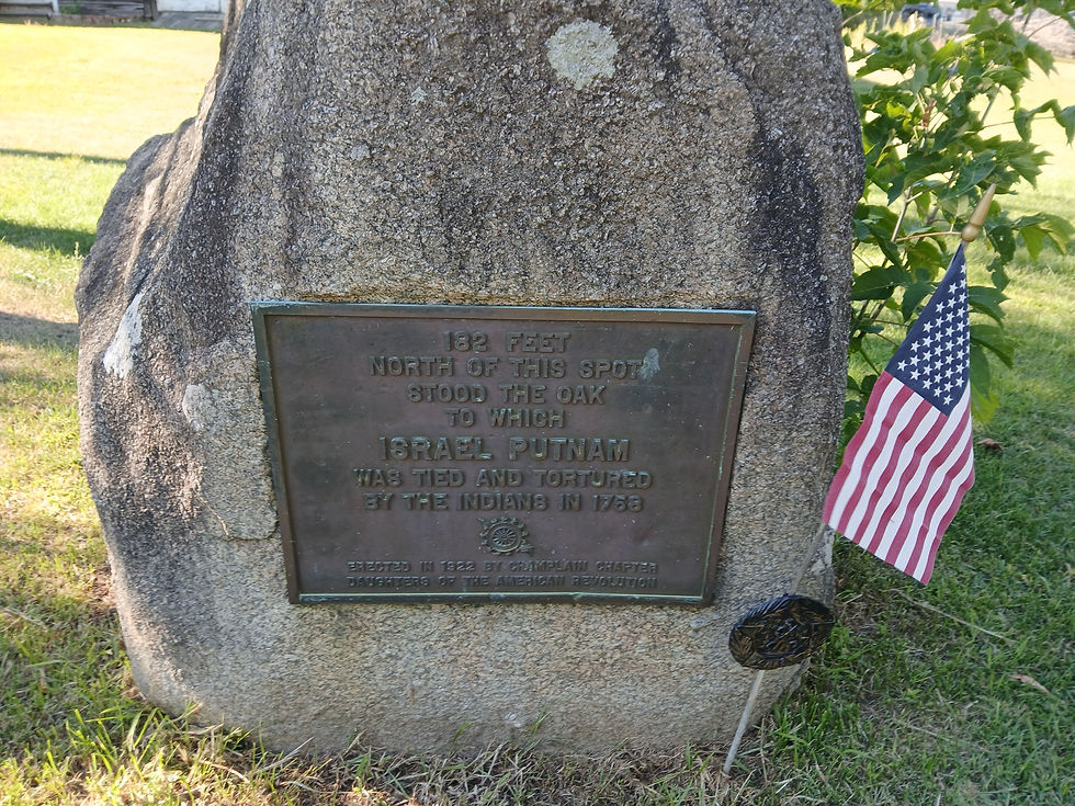
In this skirmish however, Israel Putnam was taken prisoner. His ordeal is the stuff of legend. He was tied to a tree, where a young warrior made a game of throwing his tomahawk as closely to Putnam’s head as he could. A French regular took his gun and pressed it against Putnam, pressing the trigger. The gun mis-fired. Instead, the French officer took the butt of the gun and rammed it into his face.
Gunfire broke out again, and Putnam was cut down from the tree during the French retreat. Bullets tore his clothing on the march. At the encampment later that night, Putnam was once again tied to a tree, and piles of brush were placed at his feet to start a fire. The warriors had lit the fire, but a sudden downpour extinguished the flames. A second attempt was made to start a fire when the previously mentioned Joseph Marin de la Malgue discovered the activities, kicked away the brush, and untied Putnam. He was likely looking for intelligence.
Putnam was taken back to Fort Carillon and was part of a prisoner exchange later in the year. Putnam Creek in Crown Point alludes to his captivity and torture, as it was believed to have happened in the vicinity of the creek. Israel Putnam would eventually enlist with the Continental Forces during the Revolutionary War and played a key part in the Battle of Bunker Hill.
The British Navy on Lake George
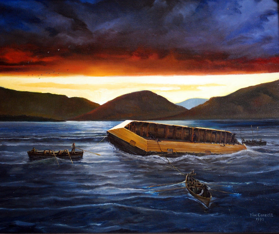
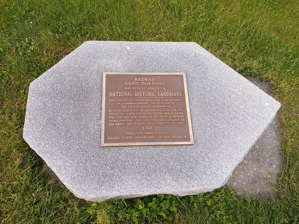
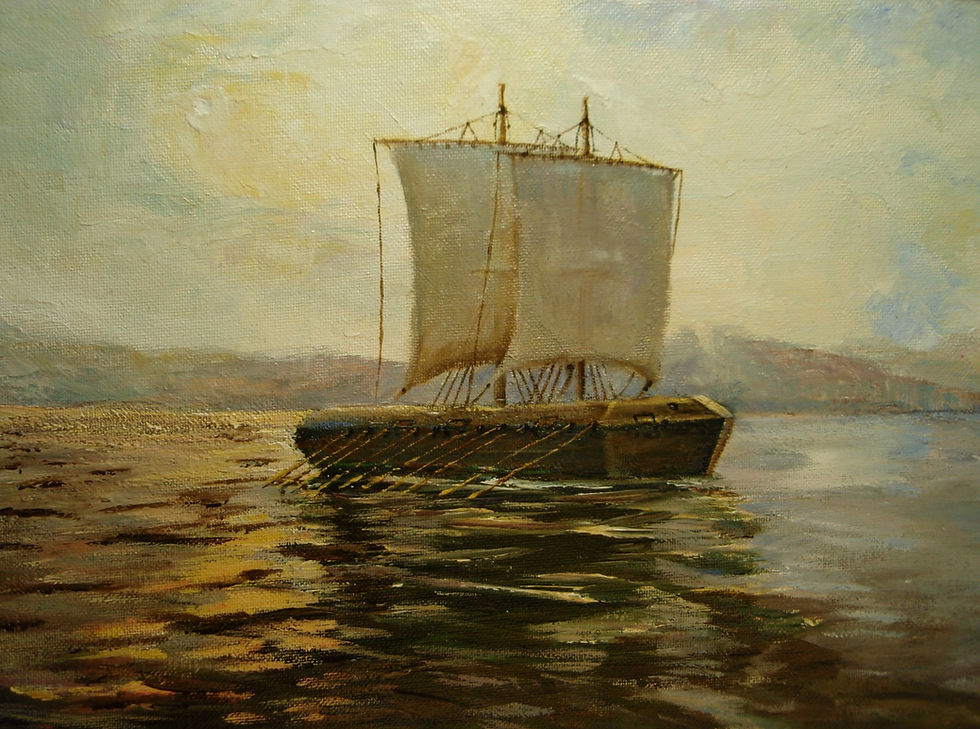
Efforts began in earnest to strengthen the British naval fleet on Lake George. Late in the summer, the 100 ton sloop HMS Earl of Halifax was launched. It was 50ft. Long with 18 cannon and 20 swivel guns. In addition to the sloop Halifax, the British also built what was called a radeau. It was essentially a floating battery, and was a very unique naval vessel to the Lake Champlain/Lake George corridor. Describing the vessel proves challenging. The British troops also struggled to describe the vessel. One soldier described it as a “large floaty thing”.
The radeau was 52ft. Long with seven sides. Each side had an upper and lower wall that angled in. The vessel utilized a large number of oars, and utilized one to two masts with square sails. Though these vessels had a tough time even in the best sailing conditions. The vessel was aptly named the HMS Land Tortoise.
Shortly after her shakedown cruise, the sloop, the HMS Earl of Halifax, took part in a celebration of victory. News reached the encampment at Lake George that Jeffrey Amherst was victorious, defeating the French at Louisbourg. This victory opened up the St. Lawrence for a direct route to Quebec. 63 cannon blasts were fired to celebrate.
Not long after, another celebration took place with the news of Colonel Bradstreet’s Success in capturing Fort Frontenac. Despite the dismal Fort Carillon campaign, the British forces had reason to celebrate in 1758. The British were surrounding Canada as the tides of the war had turned.
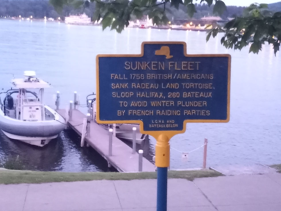
Fresh off of his victory, General Amherst made his way to the camp at Lake George. After conferring with his superior James Abercromby, the decision was made to not stage another offensive against Carillon with the season growing late. Shortly after, the vessels were intentionally sunk to prevent capture or destruction at the hands of the French. In addition, much of the heavy artillery was buried. They had a great deal of difficulty sinking the radeau Land Tortoise.
During the late fall, the French did discover the location of the Halifax, but no attempt was made to raise the vessel.
Amherst Takes Charge
A few weeks later, William Pitt recalled Abercromby as commander of forces, and placed Jeffrey Amherst in charge. This good news for Amherst was followed up by more good news. The infamous Fort Duquesne, the scorn of the British for the first few years of the conflict, had been blown up by the French in retreat. The British now finally controlled the forks of the Ohio River, the theater of the conflict that started this world war. At the site, they built a new fort called Fort Pitt, and the surrounding area was known as Pittsburgh.
As the calendar turned to 1759, Pitt’s plan was yet another three pronged attack on Canada from each direction. They would take Fort Niagara to the west on Lake Ontario, take Quebec under the direction of the ruthless James Wolfe, and take Fort Carillon and Fort St. Frederic on Lake Champlain. Leading the force in the Champlain Valley would be none other than Jeffrey Amherst.
Getting a bit of a late start due to logistical strains in Albany for both the Fort Carillon and Fort Niagara campaigns, Amherst finally arrived at the head of Lake George. He immediately began construction on a number of blockhouses along the road from Fort Edward to Lake George to counter the continual French and native raids. He also began construction on a new fort at the head of Lake George called Fort George. Fort George was built to the east of the former Fort William Henry on the site of the 1755 Battle of Lake George. Another stockade fort closer to the lake was also constructed.
They dug up the artillery from the failed 1758 campaign, and raised and repaired the Earl of Halifax. They were unable to locate the radeau Land Tortoise. The vessel would remain hidden in the depths of Lake George until 1990, when the vessel was discovered in over 100 feet of water. It remains there, well preserved, as a national historic landmark. It is believed to be the only radeau left intact.
The British Capture of Fort Carillon
Construction began on a replacement radeau called the HMS Invincible. After the completion, the force was ready to move north on Lake George to Fort Carillon. The force was impressive, numbering 6,500 regulars and 5,000 provincials. The combined number of British forces was 11,500. Impressive, but still less than the previous year when 17,000 failed to take Fort Carillon.
At Fort Carillon, roughly the same number of men as the previous year were stationed at the French fort - just over 3,000. They were under command of Francois-Charles de la Bourlamaque. Although the numbers of French defenders were the same, things were very different this time around.
Back in France, the decision was made to focus on the European theater of the world war, known globally as the Seven Years War. This meant New France would receive little, if any, support from the mother country. And what few men and provisions were sent would have to get through the British, who now controlled the entry to the St. Lawrence River. New France was left on her own.
Furthering difficulties in Canada, yet another poor harvest resulted in many Canadians living off of rations. Things looked bleak for New France.

Back on Lake George, Amherst’s forces moved north, anchoring for the night in present-day Hague. The next day, they landed at the northern end of Lake George, in present day Weeds Bay just south of Black Point. They made their way to Fort Carillon. This time, with their heavy artillery. By July 22nd, they had reached the site of the French sawmill, which they left in disrepair. This sawmill was at the lower falls of the La Chute River.
By the next day, they had made their way to the famed French Lines, the site of Montcalm’s miracle. The cross that Montcalm had erected was still visible. There was no sign of the French, who had retreated back to the fort proper.
As Amherst’s men emerged from the wood line, the cannon from Fort Carillon opened fire. The French lines actually made a very nice defense for the approaching British forces. The firing was out of range, but persisted at a furious rate. It must have become apparent what the French were doing. They were spiking the cannon: firing them in such rapid procession that was intentionally ruining them so the British could not use artillery.
Unknown to Amherst, Bourlamaque had strict orders from Governor Vaudreuil to NOT defend either Fort Carillon or Fort St. Frederic, but to remain at the fort until the very last minute to force Amherst to waste time and resources in siege warfare and trench building. The firing from Fort Carillon continued while Amherst brought the large siege guns forward.

At 10pm on July 26th, just as the British were preparing a large-scale offensive for the next day, several French deserters ran towards the British with news that the fort had been abandoned. Not only that, but a fuse was lit in the powder magazine to destroy the fort. Amherst offered 100 guineas to any daring individual to attempt to put the fuse out, but he found no takers for the mission.
Just before 11pm, a loud explosion lit up the night sky. Debris flew up, in a sight which must have looked like violent fireworks from a distance. The blast had destroyed the powder magazine and destroyed a bastion, but largely the fort was intact with some damages that could be repaired. The French had failed to thoroughly blow up the fort in their retreat, and gave the British a valuable fortification.

The next day, the British entered the fort they had waited so long, and given up so many lives to capture. The Union Jack was raised. At this point, Fort Carillon became known as Fort Ticonderoga. The powder magazine and wooden structures continued to burn for four days. More importantly, the British now had unlimited access to the southern end of Lake Champlain.
The British who entered the fort were quite impressed by the fortress. After inspecting Fort Ticonderoga, Amherst decided to immediately make repairs using the original French design. A British scouting force moved north to see what the status was on Fort St. Frederic. They returned and shared the news with Amherst that the French had also retreated from Fort St. Frederic and blew up the fort. The majestic, medieval looking fortification that had been the scorn of New York and New England for the last 20 years was now gone. With that, the British controlled southern Lake Champlain.
Amherst went north to Fort St. Frederic to inspect the area. Upon arriving, he found the fort was thoroughly destroyed and was not repairable. The nearby French settlement around the fort was also abandoned, leaving only smoldering chimneys behind. The eastern side of the lake, in present day Vermont, received the name Chimney Point as a result.
Amherst was relieved, albeit a little puzzled that the French would not make a stand. What were they up to? Should he move north on the Lake? Was this a ruse for a clever ambush?
His Majesty's Fort at Crown Point

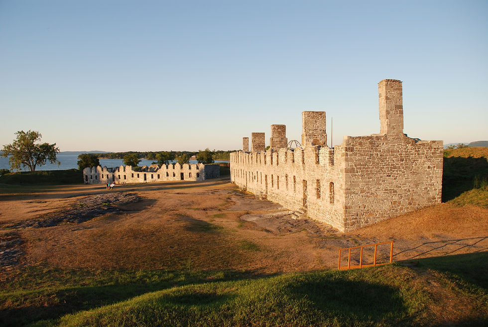
While he was puzzled over what to do next, he set upon building a new fort, just to the west of Fort St. Frederic. This new British fort would be much larger than the French fort. In fact, once completed, this fort would be the largest British fortification in North America. It was also the most expensive. The new fort was called His Majesty’s Fort at Crown Point. To design the fort was none other than William Eyre, the designer of Fort William Henry back in 1755. The walls were 23 feet thick. The parade ground was 6 acres, and the fort was designed to station 4,000 troops.

Amherst also ordered the construction of two roads emanating from the opposite shore on Chimney Point, One would lead overland to Fort Ticonderoga. The other would cut through the wilderness across what is now Vermont to Fort Number Four on the Connecticut River. This was known as the Crown Point Road.
But another issue had to be dealt with before he could proceed north. He knew of the French Navy on Lake Champlain and knew the British needed an answer.
The French fleet on Lake Champlain featured a large schooner called La Vigilante with 10 cannon. In addition, there were three Mediterranean-style sloops called xebecs. They were each named after prominent fish species on the lake. The vessels were La Musquelongy, or Muskellunge and had 10 cannon. The other two, La Brochette, or Pike, and L’Esturgeon, or Sturgeon, had 6 to 8 cannon. The commander of the French fleet on Lake Champlain was Jean d’Olabaratz. Under his command, however, was Joseph Payant St. Onge, the Master of Lake Champlain. He had been sailing the lake since the construction of Fort St. Frederic, sailing supply vessels up and down the lake. He knew Lake Champlain like no other, arguably more so than future commanders on the lake like Benedict Arnold and Thomas McDonough.
To counter this, The British began building their own fleet for Lake Champlain. It would have been too difficult to move the Lake George fleet over to Champlain, so they set about construction of the Champlain fleet. For this, they turned to Captain Joshua Loring. Loring’s son would be one of the biggest protagonists of the Revolutionary War due to his treatment of continental prisoners in New York City aboard the infamous prison ships.
The British Construct a naval fleet on Lake Champlain
Under Loring, the British built the HMS Boscawen, a 65 foot sloop with 16 cannon and 22 swivel guns. To this day, her hull remains on the lake’s bottom between Ticonderoga and Mount Independence, discovered in the early 1980’s by the Lake Champlain Maritime Museum. In addition, they built the HMS Duke of Cumberland, a 100 foot long brig with 18 cannon and 22 swivel guns. Lake Champlain would also have its own radeau, the HMS Ligonier, measuring in at 84 feet long with 6 cannon. Three smaller radeau were also built later on.
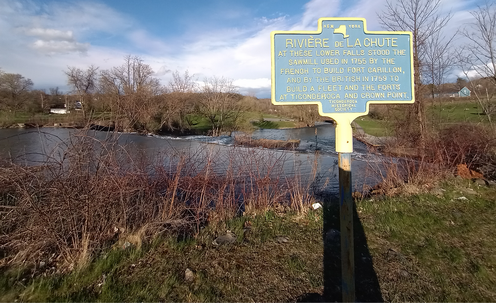
The construction of these vessels did not come without issue, though. The repaired sawmill at Ticonderoga at the lower falls was under a lot of stress. Timber was required not only for the British sailing fleet, but also for the construction of His Majesty’s Fort at Crown Point. There were several breakdowns at the sawmill, resulting in costly delays.
Back at Crown Point, Amherst lamented the lack of intelligence regarding Wolfe’s mission to capture Quebec. Everything hinged on that campaign. If Wolfe succeeded, Amherst could move north and engage with the French, who had retreated to Ile aux Noix. Ile aux Noix is a small island in the middle of the Richelieu River, just 7 miles north of where Lake Champlain empties into the river at the current international border.
But, if Wolfe failed to capture Quebec, which was more likely in Amherst’s opinion, the entire force at Quebec, which was more than half of the forces available in New France, would be freed up to reinforce Ile aux Noix. In command of the French forces at Quebec was none other than Louis-Joseph, Marquis de Montcalm. The leader of the force that destroyed Fort William Henry in 1757 and the leader who defeated a British force five times larger than his at Fort Carillon in 1758. Amherst’s fear was Montcalm’s force strengthening Ile aux Noix.
To gain intelligence on the Quebec campaign, Amherst sent Captain Quinton Kennedy. Kennedy was with Braddock on the fateful ambush in 1755 in the Ohio country.
Officially Kennedy was on a mission, under a flag of truce, to give information to the Abenaki at St. Francis and Becancour the status of Amherst on the lake, and to offer the hand of friendship. He had a long wampum belt in hand as a symbol of friendship. Unofficially, Kennedy’s real mission was to give Wolfe news from Amherst regarding his progress on Lake Champlain.
Kennedy made his way to the Abenaki settlement, going north on Lake Champlain to Missisquoi Bay, and over to the Yamaska River. Just outside of the settlement, Kennedy and Lieutenant Archibauld Hamilton were taken prisoner, despite the flag of truce. They were taken to Montcalm in Quebec. Montcalm had learned from Bourlemanque at Ile aux Noix from a British deserter that the real mission for these two men was to make contact with Wolfe at Quebec. They were captured in plain clothes, and as such Montcalm had every right to treat them as spies and sentence them to death. He did not, and instead opted to treat them as prisoners.
Montcalm penned a letter to Amherst sharing that Kennedy and Hamilton had been arrested, and in addition, Montcalm was still in control of Quebec. Amherst had the perfect motivation for a larger raid on the Abenaki settlement at St. Francis. The fact that two men under a flag of truce were arrested was a gross mis-step. This despite the real mission to make contact with Wolfe at Quebec. In fact, if anyone was guilty of abusing the flag of truce, it was Amherst himself. But, Amherst now had his propaganda. Not that he needed any to motivate the British forces against the Abenaki.
Rogers Raid on St. Francis
For this mission, Amherst turned to none other than Robert Rogers himself. He would lead a force of 250 men north to St. Francis to exact revenge. His orders from Amherst were clear. They were to remember the brutalities of Fort William Henry, in addition to the many Abenaki raids that had ravaged New York and New England since the 1690’s.
Robert Rogers himself knew of these raids all too well. As a child, his family farm in New Hampshire was destroyed by an Abenaki Raid. Several citizens of his home town were slain in this same raid. Since that day, he detested the Abenaki and sought every form of revenge that he could.
On the side of the Abenaki, these raids were meant to discourage the English land grabs in their territory. Amongst the Abenaki were many refugees of the English wars against the First Nations of southern New England. The Abenaki learned all too well that the English were prone to violent removal of native tribes when they wanted their land.

In Amherst’s instructions to Rogers, he states “remember the barbarities that have been committed by the enemy’s Indian scoundrels on every occasion…which they have done without mercy. Take your revenge, but don’t forget that tho[gh] those villains have dastardly and promiscuously murdered the women and children of all ages, it is my orders that no women or children are killed or hurt.”
Rogers set out with his 250 man force in 17 whaleboats from Crown Point, heading north on Lake Champlain. They travelled by night to avoid detection from the aforementioned French naval fleet on the lake. It was a secret mission, but it was one that could not be done without others at Crown Point noticing the activity. Amherst set about a disinformation campaign, sending letters he knew would be intercepted that the force was headed to Oswegatchie.
Rogers and his men made it to Buttonmould Bay, or Button Bay as it’s known today, hid the boats, and slept during the day waiting again for nightfall. By the next morning, they had made it to the mouth of the Otter Creek, hiding in the wetlands that surround the area. The French fleet was close by, and Rogers had to wait for either a fog or a very dark night to sneak past the fleet. He was able to do so when the French fleet adjusted their patrolling patterns further south towards Crown Point. But illness had already ravaged his force. Just two days in, over 40 men had to turn back to Crown Point due to illness.
Now Rogers and his force were in the broad lake, making it much easier to allude French patrols and vessels. They hugged the eastern shore, eventually passing the Sandbar, a shallow and sandy area between modern day Milton and South Hero, Vermont. Following the Inland Sea, as the lake to the east of the islands is known, and still only moving by night, he eventually made his way to Missisquoi Bay.
The whaleboats were moved ashore and covered up by brush to conceal them. They also left provisions for the return journey and several Stockbridge Warriors to watch over the vessels.
However, the previously mentioned mission of Captain Kennedy and Hamilton had motivated the French to increase patrols of Missisquoi Bay, a sector that Bourlemaque had identified as a weakness. A scouting party on a routine mission had spotted the vessels and brought back an oar as evidence to Bourlemaque at Ile aux Noix. A group of 40 men under La Durantaye and Langis, two officers who had previously battled Rogers during the 2nd Battle of Snowshoes the year prior. They discovered the 17 whaleboats and sounded the alarm.
Back with Rogers force, the men had proceeded through unforgiving wetlands for two days when the Stockbridge natives came with news - the boats had been spotted. Rogers had to move with haste. More importantly, he had to come up with a new plan of retreat after the raid, now that the Lake Champlain route was no longer available.
Rogers men continued through bogs and wetlands for a total of nine days before they were on solid ground. Moccasins had rotted away, as had the feet of the amphibious force. But now they had to find a way to cross the St. Francis River. They reached the river, which was raging. They first attempted to build rafts, but that effort failed because of the raging waters. It was then decided that they would form a human chain across the river, starting with the tallest and strongest men. One by one, they formed the chain in raging chest-high water. Eventually, with great difficulty, they were able to make it to the other side.
They were a short distance from the Abenaki settlement at St. Francis. In the 20 days it took Rogers force to make it there, he had lost close to 100 of the original force to either sickness, desertion, or death.
On the evening of October 3rd, the Abenaki village was within sight. There was a celebration with singing and dancing that lasted well into the morning. This seems to have been a wedding celebration.
Rogers himself reportedly entered the village in disguise. It also appears that one of the Stockbridge warriors also entered the village, and warned the Abenaki of Rogers force and the imminent threat of extermination. Many of the villagers quietly snuck out to a safe location. Others dismissed the reports and continued on in celebration.
At 5:00 am the next morning, Rogers and his men entered the village, killing just about every native they could find. They set fire to the buildings, slaughtered the inhabitants, stole the possessions of the citizens and of the Jesuit church at the village. The only thing they did not destroy was the building where the corn was stored. This was so Rogers and his men would have provisions for the return journey.
Despite the direct orders from Amherst, women and children were amongst the slain. It was an uncontrolled massacre. A Jesuit priest was offered quarter with the force, but refused to leave his home next to the church. He perished in the flames. But before the church was put to the flame, the valuable sacred items were taken by Rogers’ men as souvenirs.
In Robert Rogers official reports, the force had killed 200 warriors. These numbers were greatly exaggerated, as most of Rogers’ reports were. The first French soldiers on the scene after the raid counted only 30 casualties. 20 of the casualties were women and children. In fact, most of the warriors had been sent out of the village to try to intercept Rogers’ force along the Yamaska River, the route the French leadership believed Rogers' men would be taking.
Vaudreuil was devastated by the news of the raid. He felt the French had failed to protect their most faithful First Nations ally, the Abenaki, despite knowledge of a large English force in the area.
Starvation and Desperation
Rogers then continued his trek not back to Lake Champlain, but rather towards the Connecticut River where the Wells and Ammonoosuc river form the Coos Intervale at their intersection with the Connecticut. This is present-day Woodsville, New Hampshire, where present-day route 302 crosses the Connecticut River.

Rogers and his men marched for eight days in unforgiving wilderness, finally making it to Lake Memphremagog. The corn from St. Francis was not enough to feed the men, and hunger and fatigue were taking their toll. In an effort to try to get some food of substance, the force decided to break up into small companies near present-day Sherbrooke, Quebec. They would rendezvous at the intervale, where Rogers had sent orders to Amherst to have provisions waiting for his men.
The enemy caught up with some of the small companies and exacted revenge. It is estimated that 40 were killed by Abenaki war parties, more than the initial raid itself. Other groups were able to snag some wild game for much needed food. Most of the companies, however, were not so lucky to secure food. They lived meagerly off of mushrooms, beach leaves, and yellow lily roots.
Hunger and desperation grew more intense. They took their leather cartridge bags, boiled them and ate them. There are also several reports of cannibalism amongst various companies who were at an extreme level of desperation.
By the time Rogers and his force made it to the rendezvous point, the provisions he had asked for were not there. Worse yet, there were coals from a fire that were still hot, so someone was there just before they arrived. Indeed Lieutenant Samuel Stevens had left just two hours before Rogers and his men arrived, taking the provisions with him. Rogers tried to signal the group, which he knew must be close, with gunfire. Stevens mistook the gunfire for that of the enemy, and instead made his way back for Fort Number Four.
Rogers and many of his men suffered severe mental and physical anguish at this point. Additional men perished because of Stevens' retreat. Lieutenant Stevens would be court marshalled, and ultimately dismissed from service.
Meanwhile Rogers eventually got his wits about him, and built a raft to go south to Fort Number Four. He did so, sending provisions north 10 days after leaving his men.
The St. Francis Raid was the height of Robert Rogers lore, and made him a household name and a hero. It was also the inspiration for the Kenneth Roberts historical fiction novel, and the Hollywood movie from the 1940 starring Spencer Tracy, called “The Northwest Passage”. However, amongst the Abenaki, the raid lives in infamy. They gave Robert Rogers the name of “White Devil”.
Amherst Moves North, then Withdrawals
Back on Lake Champlain, Amherst finally decided to move north on the lake. Amherst and his navy set out on October 11th. This date is infamous in the naval history of Lake Champlain, as this was the date of the Battle of Valcour Island during the Revolutionary War.
The next morning on October 12th, The Cumberland and the Boscawen made their way past the French fleet who was anchored at Isle aux Quatre Vents, or Four Brothers Islands as they are known today. One boat mistook the French fleet as the British in the middle of the night, and the crew were taken prisoner. The French fleet continued north, rather than engage the British vessels. Amherst took cover from contrary winds in a place now known as Ligonier Bay, just south of Ligonier Point on the larger Willsboro Point.

Later on after daybreak, a clever game of cat and mouse was set to take place. Joshua Loring spotted the French schooner Vigilante and proceeded to give chase. The commander of the Vigilante was the Master of Lake Champlain, Joseph Peyant St. Onge himself. He had laid a clever trap. In the passage between Grand Isle and North Hero, St. Onge banked hard starboard to enter the Inland Sea, or East Bay as it was known. St. Onge knew that Loring would try to cut off the French vessels by sailing in between Two Brothers Islands, today’s Bixby and Young Island. He knew enough about the lake to know there were several shallow shoals between the two small islands, and sure enough, the Duke of Cumberland and the Boscawen ran aground. St. Onge sailed away into the Inland Sea having outwitted the newcomer to the lake. To free the Duke of Cumberland, all of the men had to get off the vessel, and they had to offboard another 8 guns.
Shortly after the Cumberland and the Boscawen were freed, they realized they had the other three French vessels trapped. Loring and these two vessels sailed south to Pointe a la Nazarde, or Flick of the Finger Point, today’s Cumberland Head. To the south near Willsboro Point, the rest of Amherst’s flotilla moved north. They were trapped. The French fleet anchored at Cliff Haven, just across the lake from Crab Island, or Isle St. Michel as it was known to the French. At Cliff Haven, just south of present-day Plattsburgh, the decision was made to scuttle the three vessels and march by land back to Montreal. They threw several cannon overboard, but did a rather poor job of destroying the vessels. Two of them were able to be raised and re-used by the British.

In 1968, two cannon were raised off of Cliff Haven that were thrown overboard when the French scuttled their fleet. The cannon were originally at Fort William Henry, and after the French destruction of the fort were mounted on the Musquellongy. One of the cannon is on display at the Clinton County Historical Society, and the other is on display at the Crown Point State Historical Site.
The Vigilante sailed back north to Ile aux Noix on the Richelieu River. And just like that, with the destruction of the French Fleet on Lake Champlain, 150 years of French control on the lake was over. Lake Champlain was firmly in the hands of the British.

At this same time, Amherst finally received word on Quebec. More than a month after the battle, he learned that Wolfe had been victorious, defeating Montcalm on the Plains of Abraham in the penultimate battle of the French and Indian War. Wolfe had ordered boats be rowed back and forth to the east of the city, convincing Montcalm that the invasion would happen at that location. Undetected, Wolfe and his men scaled the 175 foot cliffs at Anse au Foulon, and 4,000 British formed a line a half a mile long on the Plains of Abraham. Louis-Antoine de Bougainville had several thousand troops at Cap Rouge, but would take hours to get to the location. Montcalm ordered an advance in an uneven line. Double shotted volleys from two ranks broke the French lines. Quickly, 600 French were killed in a frenzy. Bougainville’s men arrived too late. Many of the veterans of Braddock’s defeat and Fort William Henry took their revenge on the French in a brutal manner. Both Montcalm and Wolfe lost their lives in the battle in a rather poetic manner.
Upon hearing the news, and witnessing the first waves of the cold winter air on Lake Champlain, Amherst made the decision not to advance on Ile aux Noix and proceeded back to Crown Point. Amherst was ever cautious, and the delay of not knowing what happened at Quebec prevented him from advancing further. He certainly could hang his hat in the fact that the British now controlled Lake Champlain, and the path to Montreal from the south, east, and west was now clear. He had full faith that 1760 would be the endgame of the French and Indian War. A clear path to victory was set.
This is Part 5 of a six part series on the French and Indian War. Click here for Part 4. Click here for Part 6.
Sources:
Anderson, Fred. “Crucible of War: The Seven Years War and the Fate of Empire in British North America, 1754-1766”
Bellico, Russell P. “Empires in the Mountains: French and Indian War Campaigns and Forts in the Lake Champlain, Lake George, and Hudson River Corridor”
Carrier, Roch. “Montcalm and Wolfe: Two Men who Forever Changed the Course of Canadian History”
Cohen, Eliot A. “Conquered Into Liberty: Two Centuries of Battles Along the Great Warpath That Made the American Way of War”
Cubbison, Douglas R. “All Canada in the Hands of the British: General Jeffrey Amherst and the 1760 Campaign to Conquer New France”
Laramie, Michael G. “By Wind and Iron: Naval Campaigns in the Champlain Valley, 1665-1815”
McLynn, Frank. “1759: The Year Britain Became Master of the World”
Millard, James P. “Lake Passages: A Journey Through the Centuries Volume I 1609-1909”
Titus, Timothy D. "An Illustrated History of Crown Point State Historic Site" NYS Office of Parks, Recreation, and Historic Preservation 1994.


